The German Bight: Shelf Geometry and Tidal Behaviour
The German Bight (Deutsche Bucht) occupies the south-eastern corner of the North Sea, bounded roughly by the Jutland peninsula to the north-east and the Dutch Frisian coast to the south-west. The area is characterised by shallow depths across the inner shelf, with the Wadden Sea tidal flats extending for up to 20 kilometres seaward of the mainland coast.
Tidal behaviour in the Bight is dominated by a semi-diurnal M2 tidal constituent, producing two high waters and two low waters per day. The semidiurnal period means the flood and ebb cycle each last approximately six hours, though the slack water period between flood and ebb can be brief in constricted channel sections. Spring tides occur around new and full moon, with tidal ranges approximately 20% higher than mean conditions; neap tides reduce the range by a similar proportion.
The mean spring tidal range increases progressively along the coast from west to east across the German Bight. At the island of Borkum in the west, the mean spring range is around 2.5 metres. At Cuxhaven at the Elbe entrance it reaches approximately 3.7 metres. At Wilhelmshaven on the Jade estuary the figure is similar. These figures come from BSH (Bundesamt für Seeschifffahrt und Hydrographie) published tide tables, which are revised annually and should be consulted for current predictions.
Major Channel Approaches
The Elbe Approach
The outer Elbe approach is marked by a series of light buoys and sector lights leading inward from the outer Elbe buoy (position approximately 54° 00' N, 08° 07' E) to Cuxhaven. The main channel, the Fahrrinne, carries the primary commercial traffic. Vessels approaching Hamburg follow a defined track through the Elbe traffic separation scheme.
The Elbe approach channel has been progressively deepened over several decades. Even so, the largest container vessels require tidal assistance — meaning they time their transit to use the rising tide to increase under-keel clearance during the inbound passage. The channel passes by the Scharhörn flat, an uninhabited sand island that migrates over years and decades. BSH updates charts periodically to reflect these changes; the most recent Notices to Mariners should be checked before any passage.
The Weser Approach
The Weser approach leads to Bremerhaven (approximately 130 km from the outer approach buoy) and to Bremen (approximately 65 km further upstream). The outer approach passes through the Hohe Weg and Tegeler Plate channels. The lighthouse at Hohe Weg, standing in the fairway on a concrete caisson, provides a key leading mark.
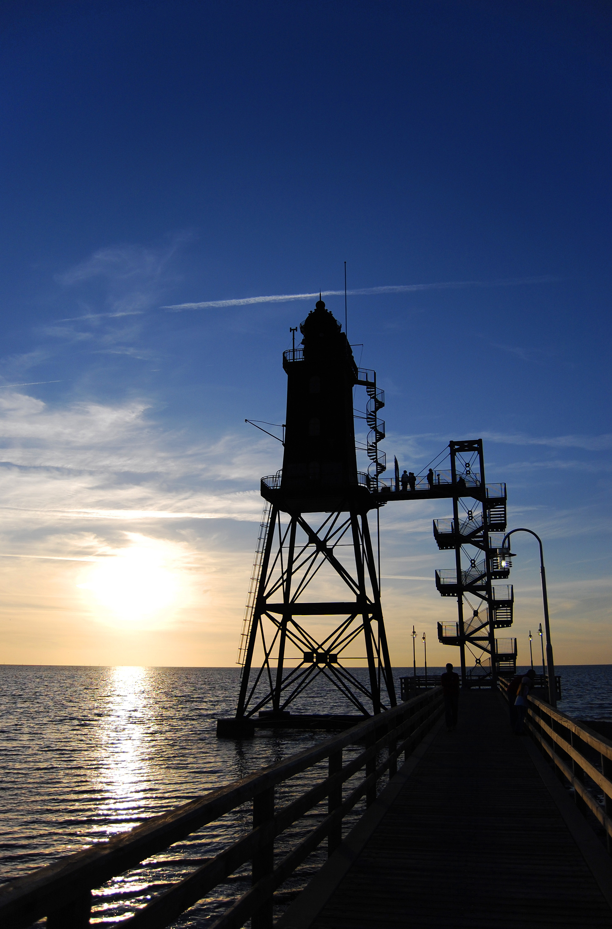
The Roter Sand lighthouse, positioned at approximately 53° 51.5' N, 08° 00' E, marks the approaches from the north-west. Built between 1880 and 1885 as the world's first screwpile lighthouse constructed in open sea, it was decommissioned in 1986 and is now a listed heritage structure. Navigational duties were transferred to light buoys and the Mellumplate lightship position.

Roter Sand lighthouse marks the outer Weser approach. Constructed 1880–1885, it was the world's first lighthouse built on screw piles in the open sea. (Wikimedia Commons / CC)
The Jade Approach and Wilhelmshaven
The Jade leads to Wilhelmshaven, home to the only deep-water port on the German North Sea coast capable of handling very large crude carriers. The Jade approach channel is narrower than the Elbe and runs through shallow flats on both sides. Tide tables for Wilhelmshaven are maintained by BSH and form the reference point for tidal predictions across the central German Bight.
Sandbank Migration and Chart Recency
The German Bight's sandbanks are not static. The Watt deposits shift in response to storm events, seasonal current variations and the overall sediment transport budget of the Wadden Sea. Surveys conducted by BSH use multibeam echo sounders and are incorporated into updated charts and Notices to Mariners. Key areas of concern include the Großer Vogelsand, the Blauortsand and the shifting banks near the Elbe mouth.
Mariners should note that electronic chart updates may lag behind physical changes, particularly after significant storm events. The BSH website publishes Notices to Mariners (Berichtigungen) that should be applied before any coastal passage.
Tidal Window Planning
Deep-draught vessels transiting the Elbe or Weser must plan tidal windows carefully. The calculation involves:
- Vessel's maximum draft plus a safety margin for under-keel clearance (typically 10% of draft, or a minimum 0.5 m)
- Charted depth at the shallowest point on the planned route
- Predicted tidal height above chart datum at the time of transit
- Any residual surge or surge deficit affecting actual water level
BSH publishes tidal predictions for the major ports and several secondary stations. The Bundeswasserstraßen-Verwaltung (Federal Waterways Administration) operates the current information service for the Elbe and Weser traffic.
Storm Surges and Surge Warning
The German Bight is one of Europe's most storm-surge-prone coastlines. The combination of shallow water, a semi-enclosed geometry and the prevailing north-westerly storm tracks during autumn and winter can produce surge elevations several metres above normal high water. The catastrophic storm surge of February 1962 caused widespread flooding in Hamburg and the coastal lowlands, killing over 300 people. This event drove the construction of the current coastal defence system, including the Hamburg flood barriers.
The BSH operates a storm surge warning service, and the DWD issues coastal gale warnings integrated into the general maritime forecast area system. Mariners should monitor both BSH storm surge reports and DWD coastal warnings during periods of strong north-westerly winds over the North Sea.
Tidal Stream Data
Tidal stream information for the German Bight is published by BSH in the form of tidal stream atlases. These show predicted surface current direction and speed at hourly intervals before and after high water at a reference port. For the outer Elbe approach, currents during spring flood can reach 2 to 3 knots in the main channel. During ebb the current sets seaward and can briefly reverse the apparent track of a vessel with limited speed through the water.
| Location | Mean Spring Range (approx.) | Mean Neap Range (approx.) | Reference |
|---|---|---|---|
| Borkum | 2.5 m | 1.7 m | BSH Tide Tables |
| Norderney | 2.5 m | 1.6 m | BSH Tide Tables |
| Cuxhaven | 3.7 m | 2.5 m | BSH Tide Tables |
| Wilhelmshaven | 3.9 m | 2.6 m | BSH Tide Tables |
| Hamburg (St. Pauli) | 3.6 m | 2.4 m | BSH Tide Tables |
Approximate tidal ranges; consult current BSH published tide tables for precise predictions.